The air dispersion modelling will be conducted using USEPA approved modelling software – AERMOD – developed by Lakes Environmental. The package titled AERMOD VIEW has three interfaces namely – AERMOD, ISCST3 AND ISC-PRIME.
- AERMOD is based on planetary boundary layer theory and uses essentials of ISC model. It also incorporates the plume rise enhancements of ISC-PRIME model.
- ISCST3 is a steady state Gaussian plume model widely used to access pollutant concentrations from a wide variety of sources andISC‐PRIME includes enhanced plume dispersion coefficients due to the building turbulent wake and also reduced plume rise caused by a combination of descending streamlines in the lee of the building and the increased entertainment in its wake.
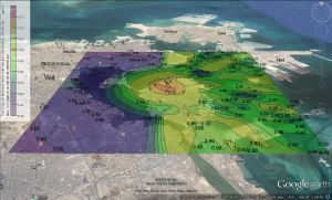
AERMOD has also a 3D view output which can be used to illustrate the results in a pictorial manner. It has various other features such as multiple chemicals modelling, integrated contouring, digital terrain data, graphical input, etc. It also includes meteorological tools such as AERMET View (processes metrological data for AERMOD), RAMMET view (processes meteorological data for ISCST3 and ISCST‐PRIME) and WRPLOT view (generates wind rose, frequency tables and graphs from the surface data files).